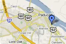
View Larger Map (Powered by |
The operating port facilities are located on Wayne Sullivan Drive, a four-lane primary city access route. This four-lane route connects with US-60 and US-62 only one mile from the port and with I-24 only four miles from the port. I-24 provides access that enables the port to serve southern Illinois in addition to the surrounding counties in Western Kentucky. These National Highway System roadways offer excellent opportunities for shipment of commodities by truck.
Rail service at the port is provided by a short line railroad, the P & L. The P & L connects in Paducah with two Class I railroads, the BNSF and the CNR, plus with a third Class I, CSX, in Louisville. This rail network offers rail service to major industrial areas including Memphis, New Orleans, St. Louis, and Chicago.