View Larger Map (Powered by |
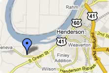
The operating port facilities and available industrial properties are located near Ky-136, US-60 West and KY-425 on the west end of Henderson Kentucky. These roads connect with US 41, Breathitt/Pennyrile Parkway ( Future I-69 corridor) and within 45 minutes of I-65 to the north.
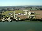
Rail Service at the port is provided by CSX, which provides service to numerous local and regional industries. The port owns 12,800 feet of track designed to service bulk and general cargo needs. Products such as fertilizer, coke, distillers grain, aluminum and zinc are delivered to the port everyday via rail, river and road.
| Market | Hours |
|---|---|
| Atlanta | 8 |
| Chicago | 7 |
| Cincinnati | 5 |
| Evansville | 0.5 |
| Indianapolis | 5 |
| Kansas City | 9 |
| Louisville | 2.5 |
| Memphis | 4 |
| Nashville | 2.5 |
| St. Louis | 3.5 |